
The Role of Imaging in Modern Drone Technology
- Kent Shore

- Jun 16, 2025
- 4 min read
The advancement of drone technology has revolutionized numerous industries, transforming how we capture and analyze data from above. One significant aspect of this transformation is imaging, which plays a vital role in enhancing the capabilities of drones. From aerial photography to advanced thermal imaging, the applications of drone imaging are vast and impactful. This post will explore the various facets of imaging in modern drone technology, how it is used across different sectors, and its significance in delivering quality outputs.
Understanding Imaging Services
Imaging services offered by drones encompass a wide range of functions, each serving a specific purpose. Drones equipped with high-resolution cameras can quickly capture images and videos from various heights and angles, providing a unique perspective that was once challenging to achieve. These services are not limited to just photography but also include thermal imaging, multispectral imaging, and LiDAR scanning.
High-resolution imagery allows for detailed inspections and surveys, particularly in sectors like agriculture, construction, and infrastructure. For example, a drone can capture detailed images of crop health, leading to better agricultural decisions. The ability of drones to fly over large areas and provide real-time data is invaluable.

Applications of Drone Imaging
Agriculture
In agriculture, drones are used extensively for crop monitoring and management. Imaging technology allows farmers to assess crop health more efficiently than traditional methods. By employing multispectral imaging, drones can capture images that highlight plant health variations, enabling farmers to apply resources precisely where needed. For instance, a farmer can identify stressed areas of a field and target them with additional nutrients or water.
A notable study by the American Society of Agricultural and Biological Engineers found that drone imaging can decrease input costs for farmers by up to 15% while boosting yields. This advantage showcases why integrating drone imaging services into modern agriculture is not just a trend but a necessity.
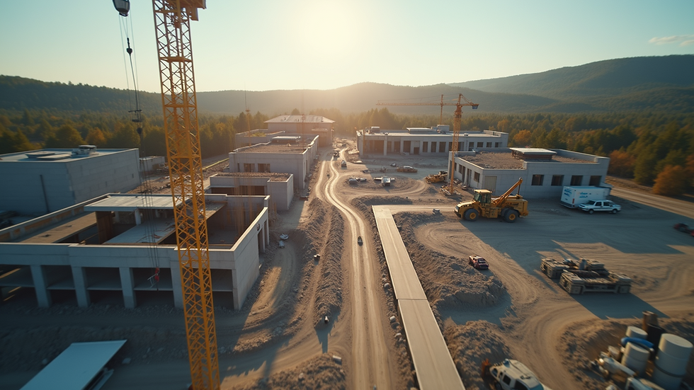
Construction and Infrastructure
Drone imaging services have also made significant strides in construction and infrastructure planning. Drones equipped with high-quality cameras can capture detailed images and videos of construction sites, aiding project managers in monitoring progress and ensuring safety compliance.
Aerial imagery can help detect potential issues before they escalate. For example, if a drone captures bumpy terrain or uneven surfaces during a road construction project, crews can immediately address these issues, significantly reducing rework and material waste. Over time, using drone imaging services can lead to higher quality projects and improved efficiency.
Disaster Management
In disaster management, drones play a crucial role in assessing damage and planning recovery efforts. Following natural disasters like hurricanes or floods, drones equipped with imaging technology can survey affected areas and capture crucial images.
These images can help emergency responders understand the extent of the damage, plan rescue efforts more effectively, and allocate resources more efficiently. According to data from the Federal Emergency Management Agency, utilizing drone imagery during disaster responses has improved situational awareness by over 40%.
The Future of Drone Imaging
As technology evolves, so does the potential of drone imaging services. Innovations like artificial intelligence (AI) and machine learning are beginning to influence how we analyze drone-captured imagery. For instance, AI can process thousands of images, identifying patterns and anomalies that might be missed by the human eye.
Additionally, the integration of real-time data processing will allow industries to make faster and more informed decisions. Imagine a construction manager receiving alerts about structural issues while the drone is still gathering data. This emerging capability could drastically reduce project timelines and increase overall efficiency.

Key Considerations for Implementing Drone Imaging
When considering implementing drone imaging technology, several factors should be kept in mind:
Regulatory Compliance: Each country has specific regulations governing drone usage. It's essential to familiarize yourself with these laws to ensure operations remain legal. Failing to adhere to regulations can lead to severe penalties.
Training and Qualification: Operating drones requires skill and knowledge, especially when it comes to navigating complex environments. Proper training helps minimize risk and enhances overall effectiveness.
Choosing the Right Equipment: The type of drone and imaging technology chosen will depend on your specific needs. Investing in high-quality cameras and sensors is crucial for achieving desired results.
Data Management: Captured images and videos generate vast amounts of data. Having a robust data management system is critical for storing, analyzing, and accessing information effectively.
Partnering with Experts: For businesses not equipped to handle imaging in-house, partnering with firms specializing in drone imaging can provide a cost-effective solution. Companies offering drone imaging services have the expertise and resources to deliver high-quality results.
Looking Ahead
The potential of drone imaging technology is vast, and its role in shaping industries is undeniable. As advancements continue, we can expect to see even more innovative applications emerge. Whether it’s optimizing agricultural practices, streamlining construction processes, or enhancing disaster response efforts, the role of imaging in drone technology will only grow.
Investing in drone imaging technology will yield considerable benefits, offering enhanced precision, efficiency, and cost savings. Organizations willing to adapt and embrace this technology will position themselves ahead of the curve, ready to tackle future challenges with confidence.
The evolution of drone imaging is an exciting journey that promises to redefine how we view and interact with our world from above. By understanding its applications and potential, individuals and organizations can harness this technology to drive success and innovation in their respective fields.


Comments